Barry E. Sakal Land Surveying provides commercial and residential land surveys throughout the Pittsburgh region and in Southwestern, PA. To learn more, please visit our Surveying Services page, or learn about The Sakal Difference.
If you do not see the answer to your question here, please feel free to contact Barry E. Sakal Land Surveying at your earliest convenience. We will be glad to speak with you.
How much will my survey cost?
Each property survey is different, affected by the unique nature of your property. Is the land wooded or open? How large is the property? How many corners will need to be marked? Is your need for a simple lot survey, or is the more extensive ALTA (American Land Title) survey more appropriate to your goals? Once we understand the scope and purpose of your survey, we will provide guidance as to the most appropriate land survey type along with a firm price quote.
How long will my property survey take?
Small residential surveys are usually completed within 1 to 2 weeks. Larger, commercial surveys may take from 30 to 60 days, depending on the needs of the survey. We are willing to consider expediting land surveys needed on a priority or "emergency" basis.
How definitive are your surveys?
At Barry E. Sakal Land Surveying, we consider our land surveys very authoritative. Owner Barry Sakal is experienced in Boundary Law and has successfully defended our survey results in a court room setting.
Are there different types of land surveys?
There are many different types of land surveys, from simple residential lot surveys to large acreage woodland surveys. The Cadillac of surveys is referred to as the ALTA (American Land Title) survey, which takes into account many detailed factors, including utility access to the property. Knowing the purpose for which a land survey is undertaken helps us determine the appropriate extent and cost of your survey.
How do you perform a property survey?
Barry E. Sakal Land Surveying prides itself on exceedingly thorough surveys. Depending on survey needs, our efforts include, but are not necessarily limited to:
- Finding existing neighborhood and surrounding area marker points.
- Researching courthouse records and other existing boundary records.
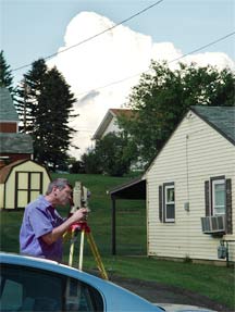
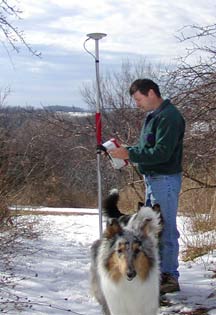
- Utilizing the latest in GPS system (Global Positioning) results.
- Accessing US Geological Survey topographical maps and orthometric aerial photographs.
- Computer research using Geographical Information Systems (GIS) and C&G software.
Are GPS system surveys accurate?
There has never been a more accurate way to perform a land survey than GPS (Global Positioning System). Measurements with GPS are accurate to within 1/16th of an inch.
Are you licensed?
Yes. It is illegal to perform survey work in Pennsylvania without a license.
Can you survey in winter?
Yes. Anytime the leaves are down is a great time to perform a land survey. All surveying equipment, including our GPS system, work better when the leaves are down. However, large snowfalls and below zero wind chills can make it impossible to provide a survey to levels of accuracy we demand.
Is courthouse work always necessary?
You may say "I have my deed, why must you do courthouse research?" The answer is that a property survey is like working a puzzle. Your neighborhood is the puzzle, and your property is only one piece. To perform an accurate land survey, we must make sure that your piece of the puzzle fits properly with all those that surround it. For larger properties, and for properties not in a recorded lot plan, we must often do extensive research into prior deeds in order to resolve all discrepancies.
Where do you find the starting point?
It is a common misconception with land surveying that there are starting points to which all surveyors go in order to perform an accurate land survey. In reality, very few land surveys have known starting point. In doing a survey, we do find a variety of marker points throughout your neighborhood, including iron pins, monuments, wooden stakes, concrete markers, and more. These physical markers are analyzed via computer and compared against neighborhood deeds, in order to provide a solution that fits the highest possible number of marker points.
Are you insured?
Yes. However, your best protection is the thorough level of work provided and our integrity. At Barry E. Sakal Land Surveying, we take every possible measure to eliminate mistakes and provide land survey results we are comfortable defending in court, should the need ever arise.
Do I have to be there?
99% of property surveys are completed with our only customer contact being by phone. Nor do you have to accompany us on the property while we perform the survey. With our reputation for exceptional customer service, we work to make your land survey process as painless as possible. From our firm quote to your final report, we will treat you with the respect and care others reserve only for their best customers.
40 Years of Experience
Hire a land surveyor with nearly 40 years experience, a land surveyor with a knowledgeable foundation in records research and a reputation for effectively employing the latest technologies.
Contact Us today for a firm, fair quote on your land surveying needs.
Service Area
Barry E. Sakal Land Surveying provides accurate land survey results for both commercial and residential clients throughout Southwestern PA, including the Pittsburgh region and the communities of Beaver, Blairsville, Connellsville, Cranberry, Ebensburg, Greensburg, Irwin, Kittanning, Latrobe, Ligonier, Mt Pleasant, Murrysville, North Huntingdon, Ohiopyle, Seven Springs, Tionesta, Uniontown, Waynesburg and more.
We have served clients in the counties of Allegheny, Armstrong, Beaver, Butler, Cambria, Clarion, Fayette, Forest, Greene, Indiana, Somerset, Washington, and Westmoreland. Our services have been required as far a field as Gettysburg, so please don't hesitate to contact Sakal Land Surveying for your land surveying needs.